ASTONISHING OFFICIALS VIEWINGS BELOW:
MARCH 4, 2021 – written by WADE QUEEN
As the city of Louisa, Lawrence County, and much of the rest of Eastern Kentucky slowly recover from Sunday night’s heavy rains that led to the severe flooding throughout this part of the state, newly found the aerial footage shows the severe amount of flooding in and around much of Louisa and Fort Gay as well with city officials saying that the river was at its highest levels in Louisa and Fort Gay areaf since 1977.
The Louisa city Police Department used the department’s drone this week to shoot several short videos showing the severe amount of flooding throughout parts of Louisa including the flooding of the water plant number two at Eloise that led to boil water advisories and no water & low water pressure issues.
The breathtaking views that are shown in the videos clearly reveal the extent of the major flooding in Louisa and also it reveals the fact the floodwaters are only slowly receding at a very small rate, even though the videos were shot two and three days after Sunday nights rains.

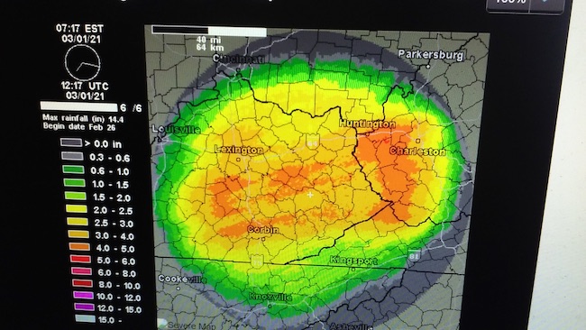
SUNRISE RAINSHINES: MONDAY MORNING RADAR IMAGE SHOWING THE RAINFALL GAUGE TOTALS FOR THE PREVIOUS 24 HOURS.
Lawrence County received the general 4 inches of rain throughout Sunday into the night except for an area between Louisa in Yatesville Lake as well as parts of southern areas of Lawrence County received up to six inches of rain on Sunday night, and in addition Lawrence County had also received significant rainfall on both Friday and Saturday before the Sunday hard rains.
However our counties to the south around both of the border rivers that suffered the most severe flooding, as they not only did they receive several inches of rain on Sunday, but also received 1 to 2 inches of rain each on Friday and again on Saturday. That much rainfall & coupled with the fact our southern neighboring counties, along with up river southern West Virginia counties, have much more steep ground terrain, which led to the catastrophic flood waters and torrential runoff that pushed water river levels to increase into a once in a half a century depths and heights.
For those who wish to check out the footage of the drone videos showing the flooding around Louisa (there are five videos in all); can see the videos by clicking on and follow the links below:


![Foothills-Bundle] Foothills-Bundle](https://thelevisalazer.com/wp-content/uploads/2020/05/Foothills-Bundle-422x74.jpg)


Funny, can’t watch unless one has Facebook.
It’s easy to download and FREE!
The videos won’t work. Says the link is broken or removed.
They work for me. You might need to refresh your browser.
I don’t use Facebook, Twitter, and friends for various reasons. One being the lopsided way they push liberalism and drown conservatives.
liberalism(TRUTH) conservatives(LIES)
more than likely that”s why it is lopsided
I have current technology probably
better than your newsroom and every link says broken its like your a cartoon version of a real newspaper it’s cute
YOU’RE TRYING TO BE CUTE BUT ALL THE LINKS WORK FOR ME. THEY’RE ON FB.
–EDITOR
Same for me. “The link is broken or removed”.
Typical Lazer
TRY REFRESHING YOUR BROWSER. ALL THE LINKS WORK FOR ME.
THE LINKS ARE NOT BROKEN. THEY ALL WORK FINE FOR ME.
Me too. They wrote back and said it worked fine for them. I’ve been trying to find a way to upload the screen grab that says the link is broken but conveniently thete isn’t a space to do that here.
Quick hint: They are FB links so if you don’t have FB they don’t work..
BINGO
Quick fact: Some of us readers don’t have and won’t have FB since it is a big waste of time.
Not our choice on posting FB videos. Sorry.
Apparently, this site is now only for Facebook sheeple.